The Philippine Association of Ultrarunners (PAU) brings another ultramarathon “to the masses,” this time to the trails. For its debut trail ultra we were taken to the site of second largest terrestrial eruption of the 20th century—Mt. Pinatubo.
I love trails. It combines my love for travelling, trekking, and running. And when I found out that the next PAU race was on trails, without giving it a second thought I said, “Yes!”

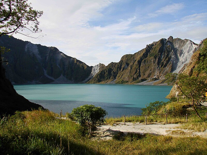
Mt. Pinatubo
Mt. Pinatubo was one of my dream destinations ever since I’ve heard its “legendary” splendor. Who would’ve thought that one of the worst natural disasters of the previous century could bring forth so much beauty? It is one hard proof that nature doesn’t need our help to be better—she can take care of herself, we just need to leave her alone.

The Trail to the Trails
I’ll admit that my funds were practically depleted coming into the race that I was open to the idea of cancelling it. It was by mere coincidence that I met Vicky (my favorite “guinea pig” for practicing my personal training skills) at the gym and asked me if I was joining PAU Mt. Pinatubo. I reluctantly confirmed my interest, but when she expressed hers with enthusiasm—well the rest was history. So I guess I have to give her credit for pulling me back into continuing with the race.
The Trailing Costs
PAU Mt. Pinatubo was one of the most stringent races when it came to first aid kit. I’ll admit my first aid kit for the past two TNF100s were merely and exclusively composed of medical plastic strips! We’ll that’s another P269 addition to my budget!
Registration fee for PAU Mt. Pinatubo, at P1,000, is quite cheap considering some 5K runs charges close to that these days, but that cost is less than half of the “real” expenses. Going to the starting line at Sta. Juliana, Capas, Tarlac, having a support crew, purchasing supplies, transport vehicle, toll fees, fuels, etc.—all these add up the costs. It was a good thing that I have reliable friends I can count on to help split the cost, and multiply the fun!

Let’s Get It Started
About half an hour past midnight last Saturday, October 09, 2010 our group departed from Manila towards Sta. Juliana, Capas, Tarlac. It was a relatively short trip (as compared to my recent “long hauls”) so there was hardly enough time to get sleep. We arrived at the starting area at around 3AM.
For this race I agreed to assist Vicky with her debut ultra. She sure is one crazy lady for attempting her first ultramarathon, on trails! Many runners I know hate the trails because it’s not easy. Since I had no intention of “making a career” with this race as this would be my shortest ultra ever (at 50K, thus the 10.10.10.10.10 🙂), might as well make myself useful and help a friend reach her goal.

The Race
About a minute before 5AM the race started. Personally I think it was too early as it was still dark and there were no light posts in the area. Fortunately some runners had headlamps so Vicky and I relied heavily on them so as not to trip.
For the first parts of the race I let Vicky set the pace, and she sure was on fire! Just as when there was enough light for us to see the path she was setting quite a good pace. Unfortunately our great start turned into a disadvantage—we got lost! Being ahead of many runners we had no one to follow on the path to take when that first “fork” was upon us. Upon instruction Sir Jovie “Baldrunner” advised us to “turn left” when confused, and we did just that as there was no marker whatsoever on which path to take. We (Vicky and I, and those that followed us) only realized our “mistake” when we heard concerned runners shouting that we took the wrong path. Darn it.

Vicky was quite furious as we ran back and eventually merged with the right path. Who wouldn’t be? We had wasted our efforts and lost time and lead—it’s something much worse than standing still as we were also burdened by the added distance. By experience, being angry with the situation and wasting energy in the process leads to nowhere, so I advised Vicky to take it easy, and took the pacing duty. I was afraid that she might have an early burnout.
I’ll admit I’m not the greatest pacer in the world—it’s either I’m up front, or behind—never beside (unless necessary). This time I was up front hoping to “pull” the one I’m pacing—not that Vicky needed it at that time, but at least I’d know if she was running too fast.
After 42 minutes we reached the first hydration station, at kilometer 7 of the route. Hydration stations were promised to be at 7K intervals and drop bags were also allowed to be placed in each. Unfortunately, this was only good in theory as we found out much later.
45 minutes later, we reached the second hydration station as expected, kilometer 14. Third hydration station, kilometer 16… say what? Apparently even 4×4 vehicles can only reach this far into the route so imagine what went through our minds when we processed the thought of being “helpless”—9 kilometers to the summit and back, that’s 18 kilometers of no support! Sheesh!

The most challenging aspect of the trails isn’t really the distance or the gradient—it’s the actual surface! For the most part you either have loose sands, or loose rocks! Then you also have quicksand and river crossings to spice things up. The quicksand was relatively harmless except for that fellow who lost his shoes in one. (Yes we did step into one and didn’t know that it was quicksand! It actually felt like stepping into soft bread or cake.) The rivers were pretty much tolerable as it’s mostly shallow, although some have strong currents. The sands and rocks on the other hand were annoying. Sand absorbs a lot of your effort leading to a very tiring run, while rocks obstruct your path making a straight path practically impossible. Combine these and the “spices” you get a pretty much exhausting race.

Inversely, the most beautiful aspect of this race was its sceneries. It’s very rare to find a place that you have a constantly beautiful landscape full 360 degrees! Tiring route, yes, but with an amazing beauty that is worth every calorie burned!

If you haven’t noticed, the pictures were taken quite late. In fact, all of it were taken on our way back from the lake! The race had a 4:30:00 cutoff to the crater lake, so for the first half of the race I planned not to take pictures (and left my camera with our support crew) and concentrate on bringing “the package” to the crater lake before then—and it was successful as we arrived at the lake around 15 minutes past four hours into the race.
The crater lake was just magnificent. I cannot find the words to justify how beautiful it was, and I didn’t have a photo to show for it! I really wanted to stay awhile and savor the sights, but then we got confirmation that Vicky was currently in the runner-up position. Oh no! There goes my picture-taking pace!
After spending only a few minutes at the lake we headed back to maintain Vicky’s position. Competitive? We were sure that the lady we overtook awhile back was just around the corner ready to snatch the lead anytime.

It was quite a blessing to have a natural water source near the lake. After 9K just about all of my 1.5L liquids were depleted, and it’s another 9K before we reach the nearest hydration station.
Despite being in pseudo-competitive mode, there’s always that moment to take pictures. I remembered I still have my camera-phone with me so that should be good enough for lack of other options. So from then on I had my phone on one hand constantly until the finish. It’s too bad that I didn’t bring it out earlier when I was at the lake.

During our descent Vicky was having some difficulty with one of her knees. This of course impaired the speed of our descent but being a tough woman she held on and still ran whenever she can. By the time that we lost the advantages of the downhills we were merely walking, and as such I had to plot the most efficient route for us.

It was pretty much boring during the last 14K of the race. It was also alarming for me as I had completely drained all of my liquids way before the next station still several kilometers away. Fortunately, removing my shirt (I was aiming to even out my tan, to no avail :() helped cool me down so I “survived” until the last hydration station on the last 7K of the race without taking any liquids.

The last 7K was a “hang in there” segment. The route was desert-like as loose sands, glare, and heat greeted us. With no shade and the sun behind us, we can feel our skin burn, particularly Vicky, so she used my shirt to cover her back. I had my backpack as partial shelter against the heat so it was my nape and forearms that got most of the burn (and in the end having a backpack tan at the back) but due to the glare even my front got a lot of tan.

As we counted down the last few kilometers Vicky kept asking if we were near. I know that she’s very tired as we were approaching 9 hours into the race. Of course I’d naturally reply “just a little bit more” with some overtly rounded down figure of how far more we have to go. I knew I was practically dragging her at that time, but never did she give up despite her worsening knees.
Finally, that last river crossing. Because there was no marker in sight and I knew we can’t afford to get lost if we were to maintain Vicky’s standing, I asked locals for directions just to make sure of our heading. Confirming we’re on target, we, slowly but surely, eased the distance, one step at a time—until finally the most sought after marker was in sight—the finish line!

It was a very long stretch to the finish line, and I knew that victory is practically in the bag for Vicky—unless by some miracle her close competitor comes dashing in to take the spot (which would make her truly deserving of the award).
And then that sweet moment of crossing the finish line—Vicky, on her debut ultramarathon trail race, women’s first runner up for PAU Mt. Pinatubo! An achievement I’m so proud to be witness of.

Post Race
I think I was quite dehydrated during the race as I observed I was a little disoriented with my actions. First I think I forgot to have my picture taken at the finish line receiving my finisher’s trophy, then I got confused which pocket of my bag I placed my phone. It’s a good thing that we finished without getting lost again, as those following us suffered.
Review
Mt. Pinatubo was one of the most tiring trails that I’ve ever done but is definitely one of the most picturesque. The route was definitely tiring because of the sands, rocks, etc. but it’s not exactly difficult (difficult means having to use all four limbs) as given the right skills you really can run most of the route, particularly on the way back. Don’t get me wrong, it’s still not easy.

As far as the race is concerned, I can’t say that it was very well executed. First off, route markers—or the lack of. Markers need not be placed everywhere, just placed where needed. Also, markers should be placed ideally at an eye level in places where it could easily be spotted—you shouldn’t have to look down to find one! There were several “forks” along the very wide route and unfortunately we didn’t see many markers, at least where it matters. It’s one thing to have a few runners getting lost; it’s another to have many runners getting lost even on their way back!

Next, the placement of hydration stations. I don’t know why they were able to promise a station at kilometer 21, but when they found out they cannot fulfill that promise in my opinion they should’ve spread the stations a bit more evenly as the stations were pretty mobile. But in fairness these hydration station never ran out of liquids and even served food.

Overall I can indeed say I had fun with this race despite its shortcomings. It’s PAU’s inaugural trail ultra run so I can’t really condemn them for their flaws—at least we can only expect PAU to get better next time. But then again, there were so many well executed trails runs prior to this one so we can’t say there weren’t any examples to learn from. Reluctantly, I’ll give a rating of 2½/5 for this race, the entire 2 points exclusively for the wonderful route. More room for improvement next time (which I’ll be eagerly looking forward to).
Acknowledgments
To Vicky, I’m so proud of your astonishing performance! You outpaced a lot of guys out there despite your injury, congratulations!
To our support crew, thank you very much for being there when we needed you. That cold drinks and that sandwich helped me cross that finish line. Special thanks to Doc Christopher Montaos for the travel arrangements, and JJ and the missus for the delicious meals.

To everyone that finished their respective races, congratulations! Until the next time!

nosebless pero tinapos ko kasi nagenjoy ako. ewan ko ba. siguro isa sa mga hilig ko ang gumala at pangarap ko ang mga ganitong patimpalak….
LikeLike
Salamat po at nag-enjoy ka sa aking kwento! Basta gawin mo lang yung gusto mo hangga’t kaya mo 🙂
LikeLike
Good job Dennis at sa iyong alaga! Buti di niyo inabutan yung balikatan exercise kungdi mas mahaba yung isusulat mo dito sa blog :))
LikeLike
Salamat! Kung naabutan namin yun malamang nasingitan si Vicky sa pwesto hehe 🙂
LikeLike
Congrats IDOL Denz ! 🙂
LikeLike
Salamat idol Marky at Congrats din! 🙂
LikeLike
WOW! Great account of the race dhenz! Hanggang basa nalang ako ng posts mo about your ultras and trails, he he 🙂
See you!
LikeLike
cool shots! tsk. ganda talaga ng Pilipinas(ung iba, hehe)..
layu dn nun ah.. congratulations!
LikeLike